


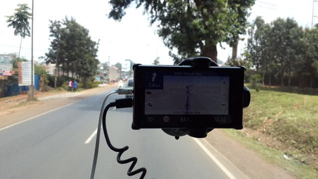
I normally don’t take Saturday’s off, they are still work days in my diary. But I took the Saturday last week off and it was worthwhile. We went with several tech bloggers and the Nokia HERE team to Naivasha on a maps feature discovery tour and there was a lot to learn, practically. The tour van we used in had a Nokia Lumia 920 fixed onto the windshield as the navigator to guide us to the destination we needed to go to, Enashipai Lodge in Naivasha.
This will form the basis of my ten reasons why you need to get lost on purpose, and here goes.
90% of cars sold with navigation use HERE maps
The Motor vehicle industry is one that requires each and every part that goes in to be of superior quality and to be trusted by industry professionals. While we were at the trip Kingori Gitahi of Nokia noted that 4 out of every 5 cars that are sold globally with navigation use HERE maps, effectively 90%. This wouldn’t be the case if the maps were second to another, you pick the best when selling premium products for the high spenders. “Now this premium feature in cars is available for free for every Nokia Lumia user,” added Kingori.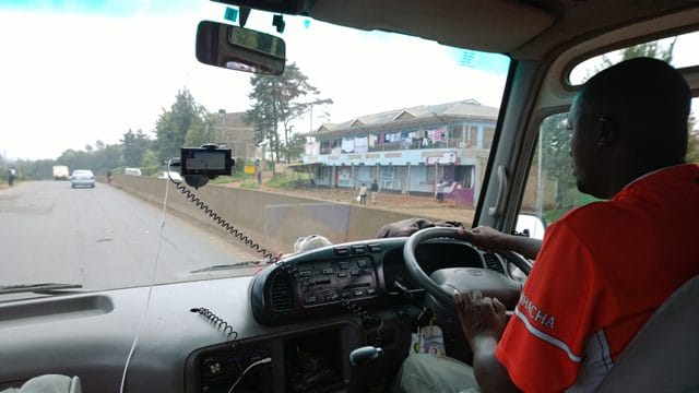
Nokia’s HERE maps have the most comprehensive local maps globally
When navigating new places, you want as much detail as possible, street addresses and the small roads that will enable you reach even those backyard joints. Nokia offers the most comprehensive local maps in the world, this includes major roads and small roads, so you can choose to go get lost in Nauru, and you will find the nearest food joint and bed and breakfast.
HERE Maps team physically verifies the points of interest
Daniel Maina, the East Africa Lead at HERE maps told us that the team at Nokia drives to the places of interest entered by volunteers and verifies that they indeed exist. In his words, you won’t find a chicken joint in the middle of nowhere like you would do on Foursquare where there is a whole lot of unverified information.
Voice guided navigation in HERE Maps
When you set a destination in Nokia Drive, you get voice guided navigation with instructions like turn left after 300 meters, what lane to use on a highway based on the destination and even recalculation in-case you missed the intended turn. Destination recalculation will happen when you miss the turn and HERE maps will show you the next route you would use to go to the destination, you even get alerted that this is a recalculation. It will recalculate again as many times as you want to play the douche. We tested this twice, once in the middle of the journey and the other when in Naivasha. This way we got to use some back-route in Limuru that I barely knew existed.
3D maps for major points of interest
HERE team develops 3D models of major points of interest, so if you enter a city for example Nairobi you will be able to identify 3D models of buildings like Nation Centre and KICC. Looks nice although this is limited to a few landmarks in major cities.
Destination mapping in major towns
In some developed countries, destination mapping where you are able to tell on what level a certain place of interest is, an example is where you can tell what floor a certain gym is in the building. Nairobi doesn’t have this although this is a future project.
Night mode on display
When driving, you are bound to meet underpasses and other dark alleys. The HERE map knows that you are in a dark place by the light sensor and will present you a night mode view of the maps for easier navigation. This is also time based depending on time-zone, I noticed that the map switched to night mode from 7pm, this is in Nairobi after the trip ended.
Categorized Places of interest
Nokia City Lens which is part of HERE maps allows you to select points of interest by category. That way you can select a specific category and avoid clutter of point of interest you don’t need, like just selecting food category and have only food joints show up in your maps. Even better, city lens will show you maps view when the phone is horizontal and when you lift it up it will show you augmented reality version of the maps showing distance and visual direction of these points.
Edit destination and add places of interest
When you have set the destination, you can then add a category of the points of interest you wish to show, like if all of a sudden you need to view the petrol stations on your route, you will add these and find your directions. Cool, huh!
Offline maps
Nokia’s HERE maps give the user ability to have the maps stored offline on the device. “When you intend to travel to a certain destination, say outside your country, you can download the map of that place via WiFi and have this available to you offline,” said Kingori Gitahi, Nokia East Africa Product Manager. “This will then be available to you even without data access and you can then proceed to use it offline, ” he added.
Just bring out the geek in you
Ofcourse, as a bonus, it goes without saying that when you pop out your phone and are navigating on the dashboard with a smartphone you are using current technology the way it’s meant to be, instead of having a smartphone that you only use to call, text and reply to emails, something that was achieved in feature phones.


