


For any person who works and lives in a city, the traffic conditions on the road is of primary importance and it can mean you will be able to arrive at the destination early or much much later. This is why we have apps that aim to update drivers and passengers alike on the real time conditions on the ground like the Google acquired Waze or our very own Ma3Route.
Waze and Ma3Route rely on people updating the real time traffic conditions on the road which are indicated on the platforms so as to update the people planning their itineraries. We have reviewed Waze and for Ma3route, we broke it down in two separate reviews so check them out.
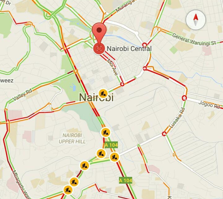
Google Maps has been providing real time traffic information to some users in other countries for a while now and it seems they are testing one for Nairobi as shown by this screenshot:

As you can see, it shows the traffic conditions by colour coding the roads in the city with three distinct colours: Green Orange and Red. According to Google’s support page:
- Green means that the road has no traffic delays
- Orange has a medium amount of traffic
- Red means that the road has traffic delays. The darker it is, the slower the traffic
There are also icons you need to be looking for in real time traffic mode. Like on the map, you can see the ![]() icon, which means there is some road construction at that point. Other icons you need to look for are:
icon, which means there is some road construction at that point. Other icons you need to look for are:
 Accident at the spot
 The road has been closed for some reason
 Any other incidents
The last update on Google Maps that was tailored to Nairobi is when they added public transit information which was rather accurate. Recently, Google also added the ability to download maps for offline use which sadly cannot work in the case of real time traffic updates.
Since this is not a formal update as of now, the only way to view the real time traffic is by requesting directions to a specific destination. Toggling the real time traffic mode by swiping left on the Maps app does not work as of now.


