Carrier signal strength is not exactly equal and you may have noticed by now that there are places that have good signal strength while some places have really poor signal strength. This is largely due to the availability of base stations around your area and as long as there are enough in your area or you’re within the line of sight, you will have a strong signal.
OpenSignal has an app that you can get on the App Store or PlayStore that allows you to know the direction of the nearest base station in your area and whether the signal strength is good or not.
OpenSignal is able to collect a huge amount of data about the state of 2G, 3G and 4G networks in Kenya from their app, and it includes data from users from Kenya.
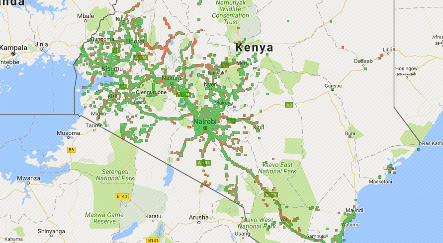
Checking out Kenya’s map reveals an interesting observation: Most of the data is located along the old railway route from the coast to the western side of the country which is not surprising since the majority of the population resides here. Also there was no data collected from the majority of the country’s expanse (northern, eastern and in the coastal regions).
The data included information from the three carriers that we have currently: Airtel, Orange (Now called Telkom Kenya) and Safaricom. You could filter out the data to determine the signal strength between the wireless technologies (2G,3G and 4G) which is great to give the extent of coverage between these technologies.
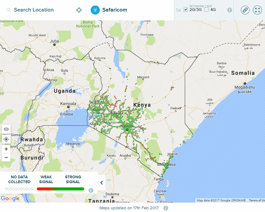
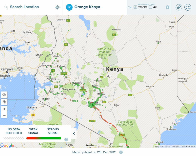
Disclaimer: The data obtained from the maps was last updated on 17th February this year. Strong signals are denoted by green spots on the map while weak signals are indicated by red dots. Check out the maps plus the ability to zoom into the specific towns or areas here
Safaricom 2G/3G
Safaricom’s 2G and 3G network is pretty extensive, covering most of the southern part of the country and in some major towns in the north part of the country. As expected, the network coverage is quite dense in Nairobi, around Mombasa and Malindi and towards the western side of the country.
However, the network is still not perfect since there are lot of weak signal spots around the country and it is very evident in places around Kerio valley and on the Athi River – Kajiado road.
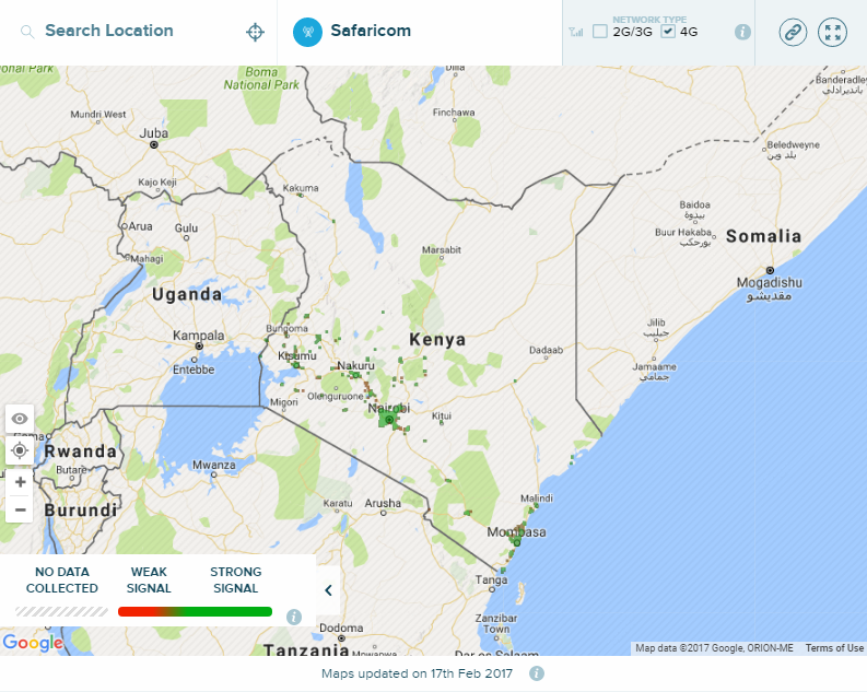
Safaricom 4G
Safaricom 4G network was launched at the end of 2014 in Nairobi initially and expanded to other towns later on. They released the faster 4G+ network recently to bolster their lead in offering such high speeds to their consumers.
In terms of the coverage, 4G is still not as extensive as their 2G and 3G coverage where they’ve first concentrated on covering cities like Nairobi, Mombasa and Kisumu and major towns like Nakuru, Macahakos, Eldoret, Meru, Nyeri and Malindi.
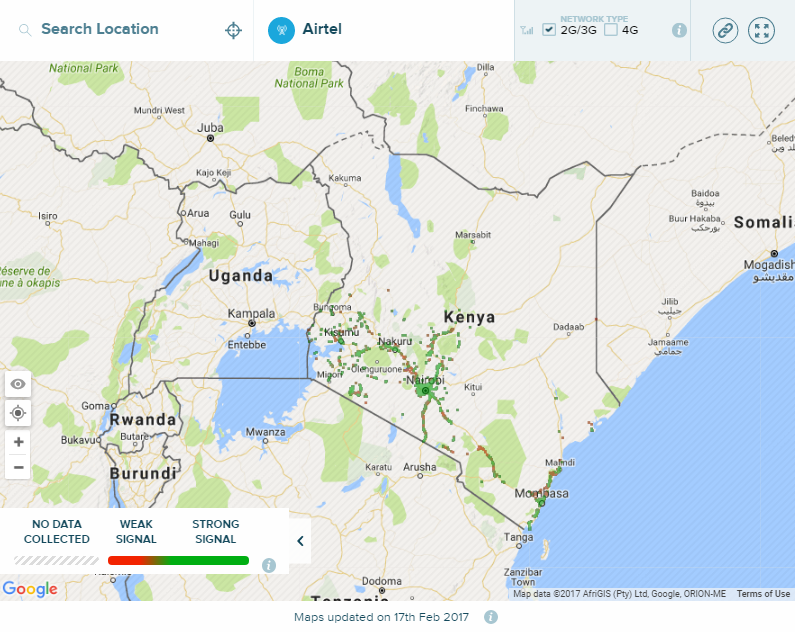
Airtel 2G/3G coverage
Airtel’s 2G and 3G network coverage map is not as extensive when compared to Safaricom’s map but they still cover the major towns and cities along the “old railway route”. There are also some prominent weak signal areas like along the Nairobi-Nakuru route and some parts of the Coast around Mombasa
Well, Airtel Kenya is yet to announce their rollout of the 4G network so their map is basically blank.
Telkom Kenya’s 2G/3G map
Orange Kenya (Now Telkom Kenya)’s 2G and 3G coverage is very interesting. It is quite good all the way from Nairobi to Nyeri but seems to be rather spotty between Nairobi and Voi. Users in towns across the western side of Kenya seem to have relatively strong signals as shown on the map.
Since this map was last updated n 17th February, it was unable to account for the launch of Telkom Kenya’s 4G coverage, which was announced during their rebranding. It is available in 9 towns across Kenya.
